Estratto del video documentario “Monte San Martino”
Monte San Martino è situato in posizione panoramica sopra la piana dell’Alto Garda.
L’area archeologica si trova a 800 m circa di altitudine, in un punto strategico per le comunicazioni dall’antico Sommolago (la piana di Riva) sia verso nord (con le regioni oltre le Alpi) sia verso ovest (con il bresciano e la pianura).
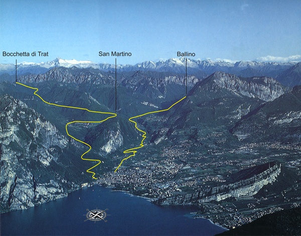
In particolare il percorso verso nord prevede il transito attraverso il passo del Ballino, le Giudicarie esteriori e Molveno fino alla Valle di Non, per raggiungere infine i valichi alpini; verso ovest, invece, superata la bocchetta di Trat, le antiche strade dovevano probabilmente percorrere le valli di Ledro e del Chiese, per proseguire fino a Brescia.
Proprio la posizione del sito risulta un motivo determinante per la sua lunga frequentazione che va senza interruzione dall’epoca pre-protostorica fino all’età moderna, con modalità diverse a seconda del periodo.
Nella seconda età del Ferro (in particolare dal III al I secolo a.C.) vi si praticano riti religiosi.
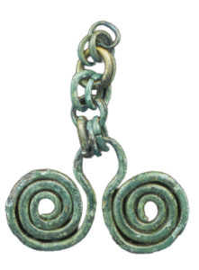
Pendaglio in Bronzo – Bronze pendant
In età romana (fine del I secolo a.C.) viene edificato un vasto complesso interpretato come santuario, rimasto in uso fino al III secolo d.C.
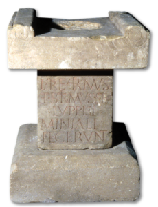
Ara I sec. d.C. – Altar, 1st century AD
Successivamente (IV-VI secolo d.C.), nella zona meridionale del dosso, si realizza un insediamento forse di carattere militare (supporto logistico), di cui fa parte un edificio di grandi dimensioni probabilmente a destinazione pubblica.
Dopo un certo tempo, nella stessa zona meridionale sorge un piccolo edificio destinato al culto. La chiesa, attestata con certezza in età carolingia (VIII-IX secolo), subisce nei secoli numerose modifiche; dedicata a San Martino è menzionata dal XIII secolo ed è officiata fino al 1750.
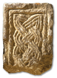
Pilastrino in pietra, IX sec. d.C. – Stone pilaster 9th century AD
THE SITE
Monte San Martino is situated in a panoramic position overlooking the plain of the upper Lake Garda area.
The archaeological site is found at an altitude of around 800m, strategically placed for communications with the ancient Sommolago area (the plain around Riva), towards the North (with regions across the Alps) and towards the West (with the Brescia area and flatlands).
Piantina dei percorsi di visita dell’area archeologica
The route to the North crossed the Ballino pass, the Giudicarie Esteriori area and Molveno to arrive at the Valle di Non, ultimately reaching the alpine passes, whereas to the West, having crossed the Bocchetta di Trat pass, the ancient roads probably ran along the Ledro and Chiese valleys, continuing up to Brescia.
It was precisely the position of the site that led to it being frequented without interruption from the prehistoric and protohistoric era right up to the modern age, the site being exploited in different ways depending on the period.
In the Second Iron Age (in particular from the 3rd to the 1st century BC) religious rites were carried out there.
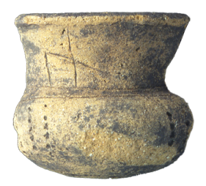
Tazza in ceramica III-I sec. a.C. – Ceramic cup, 3th-1st centuries BC
During the Roman era (end of the 1st century BC) a large complex was constructed, presumed to have been a sanctuary, remaining in use until the 3rd century AD.
Subsequently, (4th-6th century AD) a settlement developed on the southern side of the hill. This was perhaps of a military nature (providing logistical support) and included a large building probably designed for public use.
After a certain length of time a small religious building was also constructed in the same southern area. The church, which certainly existed in the Carolingian era (8th-9th century), was subjected to numerous modifications: dedicated to San Martino, it was mentioned in the 13th century and used for religious ceremonies until 1750.
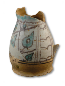
Boccale in maiolica arcaica, XIII – XIV sec. d.C. – Jug in archaic Majolica, 13th-14th centuries AD
Der Standort
Vom Monte San Martino hat man einen schönen Blick über die Ebene am nördlichen Gardasee.
Das archäologische Areal liegt auf etwa 800 m Höhe, in einer strategischen Lage für die damaligen Verbindungswege sowohl nach Norden (in die Regionen jenseits der Alpen), als auch nach Westen (in die Gegend von Brescia und in die Poebene).
Der Weg nach Norden führte über den Ballinopass, die äußeren Judikarien und Molveno ins Nonstal und von dort weiter zu den Alpenpässen. Richtung Westen führten die damaligen Wege wahrscheinlich über die Scharte Bocchetta di Trat, durch das Ledro- und das Chiesetal bis nach Brescia.
Diese Lage war sicher einer der ausschlaggebenden Faktoren für die durchgehende, wenn auch immer wieder andersgeartete Präsenz des Menschen über einen langen Zeitraum, der von der Vor-/Frühgeschichte bis in die Neuzeit reicht.
In der späten Eisenzeit (insbesondere vom 3. bis ins 1. Jh. v. Chr.) ist der Monte San Martino eine Kultstätte.
Während der anschließenden Römerzeit (Ende des 1. Jh. v. Chr.) wird eine große Anlage dort errichtet, wahrscheinlich ein Heiligtum, das bis ins 3. Jh. n. Chr. besucht wird.
Danach (4. – 6. Jh. n. Chr.) entsteht auf der Südseite der Erhebung eine Siedlung, vielleicht zu militärischen Zwecken (Versorgung), zu der ein großes, wahrscheinlich öffentliches Gebäude gehört.
Nur ein kleines Kultgebäude wird wohl von den spätantiken Strukturen verschont.
Die Kirche, die seit der karolingischen Zeit (8. – 9. Jh.) sicher belegt ist, erfährt über die Jahrhunderte zahlreiche Änderungen. Seit dem 13. Jh. wird sie als St. Martin geführt und bis 1750 wird hier die Messe zelebriert.